Saturday we decided to hike to Carson Falls. The hike to the falls started out on an Pine Mountain Road, an old fire road, which gave beautiful views of Marin County, the Richmond San Rafael Bridge, and Mt. Diablo in the distance. About a mile up we turned onto Oat Hill road, and headed west, and eventually met the trail down to the falls. Once on the trail, we were in the trees, and heading steadily down hill on switchbacks. It's about a mile down hill to the falls, and it is well worth the trip, especially this time of year. The falls were running, and a docent was at the falls, showing people the yellow legged frog, a "species of special interest"
We spent about 30 min. at the falls, having our lunch and chatting with the docent, before continuing on down into the valley. This was a steep downhill, in the woods, following the creek that is fed by the falls. For each step I took down hill, I knew there was an equal step to climb back up out of this valley. once at the bottom, we were back on a fire road, The Kent Pump Road, which was fairly level, till we connected to the Old Vine Road. This is where the uphill portion of our hike started. We gained about 1100 feet in about 2 miles, which in my book is a Huffer Puffer!
The falls were beautiful, the hike down into the canyon was spectacular, if you like to hike through redwoods, next to beautiful creeks. Unfortunately my camera was in the pack, and the pack was about 100 ft ahead of me at all times, so I didn't get any photos other than at the falls. You'll just have to do this hike to see how beautiful it really is.
Monday, March 14, 2011
Wednesday, March 9, 2011
Tea on Mt. Tam
 Saturday March 5th, we hiked the old rail road grade to West Point Inn on Mt. Tamalpias.
We started our hike at Mountain Home, off panoramic highway. While there are other ways to go, we started with Hogback, which is the fire road that connects to the railroad grade. This was a half mile of very steep grade. On a huffer-puffer scale I give it a 9, even though younger and more fit people were whizzing right past me.
Once I managed to climb, gasping, to the railroad grade, and catch my breath, the rest of the way up was easy pretty easy going.
The views were spectacular, even though it was a bit of an overcast day. the uphill climb wasn't steep, and once you get to West Point Inn you are rewarded with a beautiful spot to have your lunch, and inside the old inn you can get hot water for tea, or coffee, snack bars, etc.

From the Inn you can see Angel Island, Mt. Diablo, the peaks of the golden Gate Bridge, the pacific ocean, and on a clear day the farrallone islands.
We spent about 30 min at the Inn, talking to the Docent, having our lunch at the Picnic tables and enjoying the lovely views.
 On the return we took the trails back as opposed to the railroad grade. While the railroad grade was great, we had to share with mountain bikers. I can certainly understand why they love it there, the grade is gentle, the trail is wide, the views are fabulous, and there are lots of twists and turns. They didn't call it the crookedest Railroad in the world for nothing. The trails had the advantage of going pastwater falls, over bridges, and through redwood trees, and we didn't have to worry about mountain bikers whizzing past us.
Eventually the trail connected back on the old railroad grade, and returned back to Mountain Home Inn
 Mountain Home Inn has a lovely deck out back with spectacular views of Mill valley, so naturally we had to take advantage and have our usual end of hike adult Beverage.
This is a beautiful hike, and if you haven't done it yet, get yourself up off the couch and to Mt. Tamalpias!
Tuesday, March 8, 2011
Brush Creek
 We took a short hike in Brush Creek on Feb 28. I tried to find information on the Web about Brush Creek, with no luck. I don't think Brush Creek is it's official name. I can find the place we hiked on goggle maps, if I start searching in that area, but even on goggle maps it's not called Brush Creek. In any case, for the sake of this post we will call the wetlands off Atherton avenue Brush Creek. If you're heading north on 101, look to the East just past the Atherton Ave. exit, you'll see the wetlands off in the distance.
The weather was lovely, and the hike turned out to be very nice. But I have yet to meet a hike I didn't like.
 At first we were on a dirt road behind a housing development, so I was concerned it might not be a pretty hike, but once we got past the houses, things got very pretty.
As you follow the trail around, you start through chapparal, and eventually walk right near the waters edge. There are ducks and egrets and heron's fishing, and it was very pretty. The hike was easy, there was only one butt-burner and that was a pretty short section. We hiked a little over 4 miles, which is actually less than I like to do. I have a self-imposed rule that I need to do a minimum of 5 mi. when I go out for a hike. Actually I don't think I would even call this a hike, I think it was more of a long walk.
 This is a lovely, easy hike, and I'll give it a 3 (easy hike) and a 6 on the pretty scale. the first part of the hike is near the airport, and not too far from the highway so there are the distracting sounds of civilization .
Once you make the turn and are heading east, you get more of a feeling of being out in the wilderness, but if you look closely you can see Lakeville highway and radio towers in the distance. Still it's pretty, close in, and nice 4 mi. loop.
 There weren't many gnarley trees, but there was this spot where the trees had grown over the trail.
After the hike there was Yarn shopping, Academy awards, Beer, Wine, Champagne, and Chinese take out, so any benefit I got from the walk got canceled out, but that happens almost every time we go on a hike.
Next up: Tea on Mt. Tam!
Wednesday, February 23, 2011
Chewie
 Chewie is the name of the Targhee Sheep residing at Merry Meadows Farms. I was lucky enough to win some of his fleece, and it's mighty pretty stuff, if I so say so myself.
This photo shows the raw fleece. It was amazingly clean which is good because I swore I would never buy raw fleece again, as I'm not particularly fond of the washing process.
I had bought Targhee batts from Merry Meadows farms in the past, and it was wonderful stuff. It practically spun itself, so I was pretty excited to get 2.2 lbs of this stuff, even if I did have to wash it myself.
 I bought two lingerie bags, and put approx. 4 oz in each one and started washing, two 4-0z. batches at once.
Look at how beautiful it is washed and ready to be carded! I don't think I've ever seen fleece with a golden yellow glow to it. Leaving it in the sun to dry seemed to make it even more beautiful.
 Once it was dry, I started the carding process. I just grabbed handfuls of it, teasing it apart and tossing it into the drum carder. I carded each batt at least twice. My little Petite Strauch drum carder is joy to use.
 I now have 3 brown grocery bags full of creamy buttery batts, ready to be spun. The picture to the left doesn't really do justice to the color of the batts.
After washing, and carding I have 27.6 oz. (that includes the weight of the brown grocery bags). I had toyed with the idea of dyeing it, but I just love the natural color, it makes me think of an Aran Fishermans sweater. I don't think I have enough to do one of those though, so for now it's sitting in the bags waiting for me to decide what to make out of it. Do I want a 3 ply? a two ply?
We shall see.
Angel Island

Our Mission to get fit continues!
On Sunday we took the Ferry to Angel Island.
Angel island is my all time favorite hike. You get to ride a ferry boat, see the Immigration center, World War II buildings, Civil War buildings, Nike Missile site, not to mention spectacular views of the Bay from all directions, and the occasional Deer.
 The sun was out, but it was a bit cold when the wind kicked up. Due to the recent rains, we decided to stay on the perimeter road, rather than tromp through the muddy trails to the top of Mt. Livermore. The perimeter trail is approx. 5.2 miles, which just meets my criteria: Hikes need to be at least 5 miles.
The only drawback to the Perimeter Road is that it's blacktop, and it hurts my feet to walk that far on blacktop. Dirt trails are much easier on the old dogs.
 It doesn't matter which trail you take on Angel island, you are rewarded with views in all directions.
The newly renovated Immigration Station is well worth spending some time at, and even through we have been there several times, this was the first time we sat down for the 20 min. Video. I would suggest, even though the audio could use some work, that you take the time to watch and get an understanding of what the Chinese immigrants to this country had to endure. We headed to the left when we got off the ferry, which put the immigration center at the beginning of our hike rather than at the end, when we are rushed to get back before the last ferry leaves the island.
 And no blog post of mine would be complete with out a photo of some cool trees!
The cost for the ferry and entrance to the park is $13.50, then parking in Tiburon can be pricey too, but it's well worth the cost.
Monday, January 31, 2011
Redwoods, Gnarly Trees and Lots of Mud

On Saturday, because the weather report said it was NOT going to rain on Saturday, we headed out for our weekly hike. This time we went down to Novato, and hiked the Big Trees Trail, which is in the Indian Tree Open Space Preserve.
 This was so unexpectedly pretty, in spite of, or more likely because of the foggy misty drippy weather. The trail starts out with switch backs heading up through gnarly trees, and after about a half mile, you hit your first redwood grove. The trail continues through oak, and redwood groves all the way to the top, occasionally popping out into clearings, so you can enjoy the view. Of course in our case the view was mostly fog, but still it was very pretty.
I don't know how it is that we did not discover this trail sooner.
 I love Redwood trees, and I love gnarly trees, so this hike was perfect for me. We did a little under six miles round trip, and gained 1,440 ft. of elevation. My legs were feeling it next day too!
 As you can see it was pretty foggy, the sort of weather that redwood trees thrive on. You could hear the rain dripping off the leaves and hitting the ground, and when a breeze would blow through you could swear it was raining.
The trail was muddy, but that didn't stop us, it might have slowed us down a bit, but it didn't stop us.
 We saw dozens of these little guys (salamanders? Newts?) all between about 1" and 4" long. They were all headed to the other side of the trail, for no reason that was obvious to us. I wish I could tell which direction they were heading, but the compasses on my walking sticks each point in total opposite directions. So they were either heading West, or East, depending on which hiking stick I was looking at.
After our hike we found a spot for a cold beer, followed by a hamburger and fries and a glass of very nice zinfandel. All well and good, but if I'm going to actually lose some weight I need to find another way to reward myself at the end of each trail.
I'd love to go back and do this hike again. Every turn was beautiful, the views in the fog were so pretty, and the parts through the redwoods
 were peaceful. Except for a lone runner, and another small group of brave souls, we had the entire park to ourselves.
I know its a small accomplishment, but from one month ago, and our hike at the Pomo Canyon until now, I can really feel a difference in my fitness level. While I'm not planning to run a marathon, and I'm still always the last one off the trail, it is amazing how quickly the body responds to even moderate levels of exercise.
 Beautiful Redwood Groves. I can't wait to do this hike again, and to share it with our friends we haven't done this trail.
Monday, January 24, 2011
The Elusive Muddy Hollow Trail
 Last year about this time, we headed out towards Limantour beach, because we had read the Muddy Hollow Trail was a very nice hike, and you could start the hike from the beach, and make a loop ending up back at the Beach. Well, that was not entirely true. The portion of the trail from Limantour Beach to the Muddy Hollow trail was closed, so we ended up walking on the beach to the end of the spit and back again, which was beautiful. It was, like yesterday, a beautiful Northern California day, dry and upper 60's.
Yesterday we headed out in search of the Muddy Hollow trail again, and this time, armed with maps and a hiking guide, (California Hiking, The Complete Guide to 1,000 of the Best Hikes in the Golden State) we found the trail head. We arrived around 12:15 and after changing shoes, adjusting trekking poles, discussing the need for sweatshirts or not, we headed out to do the Muddy Hollow loop. According to the map the loop is 7.5 mi. The trail goes through all sorts of terrain, open grass lands, forests, over small creeks, and up on a bluff overlooking the ocean.
 The view of the Farallones Islands was the most beautiful I had ever seen. Normally you are lucky to see some dark shapes off in the haze, but yesterday you could make out the actual shape of the islands. My camera is not good enough to really do the view of the Farallones justice, and of course the light was all wrong, but if you look carefully you can see them off in the distance.
We stopped on the bluff to have our lunch after having gone about 2.5 mi. (according to my pedometer, accuracy of which is suspect).

I'm the slowest in the crowd, so if it weren't for me, the others would have finished the loop a lot quicker, I'm sure. Not only am I slow, but I stop often to take pictures.
I love it when I find a gnarly tree to photograph.

This hike is part of the Pt. Reyes National Seashore. You can read all about the other hikes and download maps here
Sunday, January 16, 2011
A Walk in the Park
Yesterday was a perfect Sonoma County Day, sunshine, mid 60's, perfect for a walk in the Park-- Helen Putnam Regional Park.
 The park is close to home, you can park for free in on the neighborhood side, or pay $6.00 if you park in the parking lot. We opted for the free Parking.
Even though the park is on the edge of Petaluma, once you start up the trail, you feel miles away.
We weren't the only ones out walking. The park was full of families, joggers, bikers, people walking their dogs, people riding horses, people walking their dogs while riding their horses.
The views were lovely, some a reminder that you weren't that far from civilization.
.
 This is a shot facing east. You can see Petaluma off in the distance.
There are benches scattered through the park so you can stop and enjoy the views, which we did. We found a nice spot to stop and have a bite to eat.
According to my pedometer we went 2.09 miles, but according to the map we went 3.4 miles. Maybe it's time for a better pedometer.
 Here is one of those spots that makes you feel far away from civilization.
The park has a lot going for it, its close to home, there are lots of trails so you can walk as long or as short a trek as you're in the mood for. The views are pretty, there are lots of people, so I didn't worry about mountain lions.

Facing south, from the south loop of the walk.

And this shot, just because I love gnarly trees.
We were told to come back in spring to see the wild flowers, which we will definitely do, but I think we will probably go back before then.
Thursday, January 13, 2011
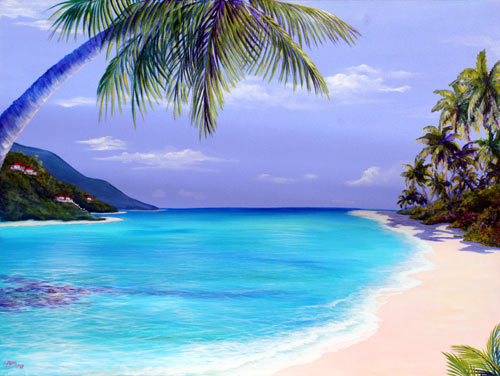
Heading to St. Croix, US Virgin Islands!
I mean look at this place...who wouldn't want to go there?
 We’ve been invited to a Wedding being held on St. Croix, US Virgin Islands, and I say what better opportunity for a little get-away.
The wedding isn't until end of April, but we have our airline tickets, hotel reservations, and passports already packed!
We’ll be staying at the Hibiscus Beach Resort.
I've been busy researching things to do and see on the island. For me, half the fun of going on vacation is the preparation and anticipation, which is particularly fun on a grey dreary day like today.
Besides just relaxing on the beach (which is what most normal people do), there is a botanical garden , the Cruzan Rum Factory, Buck Island Reef National Monument, and the usual island things: diving, canoeing, kayaking, and fortunately for us, Hiking! We have to continue getting into shape for the Milford Track even on vacation. And because we aren't the kind of people who just relax on the beach. No, not us. We have to go go go, till we practically kill ourselves seeing everything, doing everything, until finally we have to drag our sorry butts home to recover from our "relaxing vacation."
You can expect a full report when we get back, but you'll have to wait until May.
Now what knitting to take? it will be hot, muggy... socks perhaps? something in Linen?
Monday, January 10, 2011
Countdown to the Milford Track
Yesterday we went on the first Hike I’ve been on in almost a year. It was not only a beautiful hike, but a good indicator of how much work I have to do to prepare for the Milford Track.

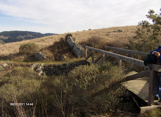
We hiked the Pomo Canyon Trail / Red Hill Loop. (The hike and beach are part of Sonoma Coast State Park).


We hiked the Pomo Canyon Trail / Red Hill Loop. (The hike and beach are part of Sonoma Coast State Park).
Since the campground  is closed this time of year, we had to park on the road and walk the half mile to the trailhead. About a mile up the hill through beautiful redwoods, the trail makes a fork, where you can continue on the Pomo Canyon Trail to Shell beach (as described in “clip and go”, and was our original plan), or head up Red Hill (elevation 1060), which is what we did. The trail up to the summit goes through grasslands, over a creek, and through another small redwood grove.
From the Summit, the views of the ocean and Russian River are spectacular. To the East we could see the steam coming up from the Geysers, forming a cloud over the mountain top. We had our lunch, enjoyed the views, and then headed back towards Shell Beach.
 This trail eventually takes you to another fork, where you can head to Shell Beach, or take the Pomo Canyon Trail back. It was getting late, and we were concerned about running out of daylight, so we didn’t go all the way to Shell Beach. We headed back on the Pomo Canyon trail, completing the loop. Just past the fork is a little outcropping with a picnic table. We stopped there for a minute or two, enjoyed the view, and rested our feet a bit before continuing on.

The hike goes through Redwood groves, grasslands, over creeks, and this time of year, LOTS of mud. On most scales, the hike is given a “moderate” rating, but in my couch-potato-condition, I give it a “difficult” rating. Let’s see a year from now if it still feels like a “difficult” hike to me.
 I particularly liked the redwood groves. There is something very peaceful about stands of redwoods, and even though the trail was very muddy in spots, the recent rains also had the creeks running. It’s a beautiful hike and we weren’t the only hearty souls out on a cold January Day enjoying the fresh air, sunshine and views. I’d like to go back in spring or summer, when the days are longer, and the trail not so muddy.
The loop we did was probably 7 mi., including the half mile walk from the road to the trailhead. We didn’t follow the Pomo Canyon trail as described which gives the distance as 5.5 mi. roundtrip on the Pomo Canyon trail. (NOTE: The “clip and go” is a bit outdated. The trail hasn’t changed much, but parking is now $8, not $3 as mentioned in the link)
Towards the end of the hike, which took us about 4 ½ hours, my legs were starting to shake, my feet  hurt, and I had some nice blisters. It’s obvious I have my work cut out for me to prepare for the longest day of the Milford Track. Day 3 is 9 miles and gains approx. 3000 ft. in elevation. Depending on when we book our trip, I have 10 – 11 months to get myself in shape.
Can I do it?
Subscribe to:
Posts (Atom)